>Net Sedimentation Tile (NST) Protocol
Home » Research » Methods » Net Sedimentation Tile (NST) Protocol

Net Sedimentation Tile (NST) Protocol

Net Sedimentation Tile (NST) Protocol For Monitoring Short-term Sediment Fluxes In Depositional Environments

sedtiles_3.gifBy Greg Pasternack

University of California, Davis
gpast@ucdavis.edu
530-754-9243


(As reported in Pasternack and Brush (1998), Pasternack et al. (2000), and Knight and Pasternack (2000))

Background

Several methods for monitoring sedimentation have been developed for a variety of depositional settings (e.g. Serodes and Troude 1984; Reed 1989; Hupp and Bazemore 1993). Marker horizons, filter paper, stage rods, tree burial dendrochronology, sediment erosion tables, and infra-red back-scatter detectors are specific examples of sediment monitoring technologies.

For floodplain and delta settings a method capable of handling spatially and temporally variable deposition rates is needed. Also, it is desirable to have an approach that yields samples for sedimentological and chemical time series analysis. To obtain these data lightweight aluminum pipes are sunk into the ground and capped with a detachable ceramic tile flush with the marsh surface. The detachment mechanism involves gluing a plastic tube to the bottom of each tile. The ceramic tile/acrylic tube assembly drops over the anchor rod and is not susceptible to motion unless subjected to extreme lift forces.

Purpose

To monitor net sediment deposition through time and relate it to hydrologic and geomrophic variables.


Materials

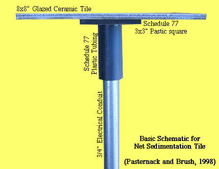
Sediment Tile components:

  • 8" x 8" square glazed-ceramic tile (kitchen tiles are suitable)
  • 3" long hard plastic pipe with an inner diameter of 3/4"
  • 3" x 3" hard plastic squares
  • Silicone glue and plastic cement
  • 3 1/3' long x 3/4" dia. aluminum tubing. Also known as "EMT conduit".
    Referred to here as the "anchor"

Installation aids:

  • GPS, 5' x 1" hand auger
  • hammer
  • 5' x 3/4" aluminum tube
  • metal file
  • (long) regular screw driver
  • pocket knife
  • duct tape
  • meter stick
  • compass
  • bright flagging
  • hand shovel
  • ruler (mm)
  • work gloves

Sample collection equipment:

  • Pre-washed, pre-weighed, pre-labelled straight glass jars with metal lids
  • Large taping knife
  • Pocket knife

Installation Procedure

"Tile assembly" preparation:
Using plastic cement, bond a 3" plastic pipe to the center of a plastic square.
Using the silicone glue, bond the other side of the plastic square to the bottom of the ceramic tile

sedtiles_1.jpg
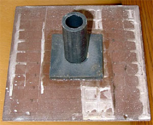
(Oblique view of the underside of an NST)

sedtiles_2.jpg


Field Installation

  • Use the GPS to locate the pre-selected tile site as exactly as possible
  • Use the hand auger to dig a 3'-deep hole at the site.
    • Try as best as possible to preserve auger cuttings in a pile near the hole
  • Put the 5' x 3/4" alum. tube into the hole. Hammer it down 4" and pull it out
    • This small hole will give the anchor tube a tight fit at the bottom
    • Use the screw driver to dig the sediment out of the 5' tube before next use.
  • Put the 3.33' by 3/4" anchor down the auger hole and into the small hole at the bottom.
    • Before you put it down, make sure that the tile assembly fit easily over the end of the anchor that will be sticking up.
    • Sometimes you may be unable to locate the small hole and will have to redo it.
    • The top of the anchor should be slightly lower than the ground surface. You may stomp on it if it is too high, but DO NOT hammer it, or the top will dent and the tile won't ft on it. If this happens you may be able to file down the sides of the anchor with the metal file.
  • Use the hand shovel to backfill the auger hole with as much of the auger cuttings or nearby surface sediment as possible.
    • Try not to leave any cuttings on the ground near the hole, or it may move onto the tile when the water floods the site.
  • Use the pocket knife to trim down any vegetation within 8x8" of the anchor.
  • Lay the meter stick on the ground with one end on the anchor and the other pointing due east.
  • Hammer a second anchor ~1.5' down into the ground at the east end of the meter stick.
  • Tie a long strip of flagging to the top of the marker anchor and duct tape it on for security.
  • Place tile assembly over sunk anchor.
    • If erosion is going to be monitored, it is necessary to record the height of each side of the tile above the marsh surface and the depth of the anchor using a ruler in millimeters. Ideally this should be zero, but with the existing microtopography there will be some variation from the idea case in some settings.

Tile Sample collection

Sediment sampling stations using the above apparatus should be visited on a recurrence interval appropriate for the type of system under study. Too little or too much sediment necessitates extra care in sampling. Recommended sampling intervals are

System type Sampling Interval
Tidal freshwater wetland 2-4 weeks
Salt marsh 4-8 weeks
Floodplain Varies with flood regime

Accumulated sediments need to be collected into a glass jar (or a large bucket in some instances on floodplains). Any vegetation lying across the tile should first be clipped at the edge of the tile and put in the jar by hand. Then, one person holds the jar while the other person uses the taping knife and pocket knife in conjunction to carefully scrape the sediment into the jar. When water content of sediment is not important, distilled water may be used to wash the tile completely clean of sediment. This is only significant when total accumulation is very low, otherwise the error is very small.

Assuming the tile was flat on the ground upon installation, erosion is recorded by measuring the height of each tile side and the anchor rod above the marsh surface and averaging the measurements. If the tile was not flat, measurements need to be adjusted for the known deviation recorded when the tile was installed. Eventually, the erosion depth will be multiplied by sediment bulk density to achieve a mass estimate of erosion. Once erosion is recorded at a site, the tile heights must be tracked from that point forward in time to account for the history of the erosion.

Where both erosion and deposition are evident, the two methods may be combined to obtain net sediment accumulation.


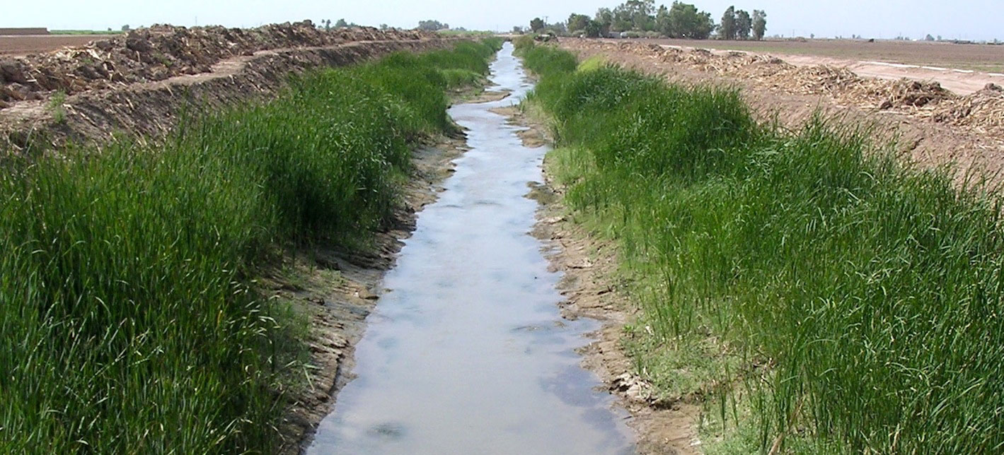
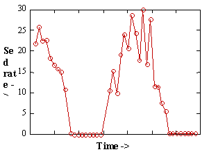
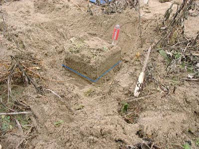
Example of Floodplain sediment deposition over a 1 year period 
(blue line indicates location of sediment tile) 
sedtiles_4.jpg

Safety Issues

No unique safety issues arise in this procedure. Some typical field hazards you might run into are poison oak/ivy, hitting your hand with a hammer, heat exhaustion, and back pain. Standard field precautions are warranted.


References

Pasternack, G. B. and G. S. Brush. 1998. Sedimentation cycles in a river-mouth tidal freshwater marsh. Estuaries 21:3:407-415.

Pasternack, G. B., W. B. Hilgartner, and G. S. Brush. 2000. Biogeomorphology of an upper Chesapeake Bay river-mouth tidal freshwater marsh. Wetlands 20:3:520-537.

Knight, M. A. and Pasternack, G. B. 2000. Sources, input pathways, and distributions of Fe, Cu, and Zn in a Chesapeake Bay tidal freshwater marsh. Environmental Geology 39:12:1359-1371.


>Net Sedimentation Tile (NST) Protocol
  • Home
  • About Me
  • Research
    • Scientific Highlights
    • Projects
      • Near-Census River Science
        • 2DMUs
        • Hydraulic Topography
        • Topographic Change Detection
        • Topographic Change Processes
        • Floodplain Inundation
        • Streamwood Storage
        • Upper South Yuba
        • Salmonid Migration
        • North Yuba River
        • Salmon Migratory Habitat
      • Geomorphic Covariance Structures
      • Synthetic River Valleys
      • Watershed Processes
        • Watershed Sediment Transport
        • Watershed Streamwood
        • Watershed Sedimentation
      • River Rehabilitation
        • Spawning Habitat Rehabilitation
        • Cobble/Gravel Injection
        • Streamwood Jams
        • Geomorphologist's Guide
      • Waterfalls
        • Horseshoe Falls
        • NSEAM 1.0
        • Hydraulic Jumps
        • Small Step Mapping
        • Small Step Hydraulics
      • Tidal Freshwater Deltas
        • TFD Introduction
        • TFD Vegetation
        • TFD Sediment Cycles
        • TFD Ecogeomorphology
        • TFD Hydrometeorology
        • TFD Sediment Transport
        • TFD Modeling
        • TFD Animal Response
        • Bush River, MD
        • Winter's Run, MD
      • Estuarine Processes
        • Salinas River Estuary
        • San Joaquin-Sacramento Delta
        • Blackwater National Wildlife Refuge
        • Long Island Sound
      • Functional Flows Model
      • Volcanic Lakes
        • VL Classification & Modeling
        • VL Bibliography
        • Keli Mutu
          • Remote Sampling Strategy
        • Lake Batur
        • Other Volcanic Lakes
      • Agricultural Sediment
      • Urban Rivers
      • Chaos in Hydrology
      • Channel Types
    • Methods
      • Net Sedimentation Tile (NST) Protocol
      • Sediment Core Processing Protocol
      • Vibracoring Protocol
      • Loss-On-Ignition Protocol
      • C-14 Sample Selection and Prep Protocol
      • Cation Sample Prep and Analysis Protocol
      • Grain Size Distirbution Protocol
      • MS Word Fig. code
      • Kite Blimp Method
      • Laser Granulometer Protocol
    • Software
      • River Builder
    • Sponsors
  • Teaching
    • SAS 004Y : Water in Popular Culture
      • Course Logistics
      • Sections
      • Syllabus
        • SAS004 Introduction
        • Water Scarcity
        • Water Scarcity Discussion
        • Floods
        • Flood Insurance Discussion
        • Water Quality
        • Water Quality Discussion
        • Water & Psychology
        • Water Psychology Discussion
        • Conquering Nature
        • Conquering Nature Discussion
        • Pro Poor Water
        • Pro Poor Water Discussion
        • Arctic Socio-Ecology
        • Indigenous Knowledge
        • Earth Stewardship
        • Earth Stewardship Discussion
        • Global Climate Change
        • Global Climate Change Discussion
        • Coastal Zone in Crisis
        • Coastal Zone Crisis Discussion
        • Course Review
      • Readings
      • Instructor
      • Classroom Behavior
      • Grading Policy
      • Movie Logs
      • Discussion Activities
      • Expository Essay
      • Study Guide
      • Online TA Help
    • ESM 125: River Conservation
      • Syllabus
        • River Conservation Introduction
        • Navigability For Title - Law
        • River Segmentation
        • Historical Hydrology
        • Indigenous River Conservation
        • Habitat Conservation Law
        • Aquatic Habitat
        • Riparian Habitat
        • Water Temperature
        • Sediment Sampling
        • Water Quality
        • CA State Water Boards
        • Biological Opinions
        • Setting Biological Goals
        • County-Level Water Management
        • River Restoration
        • Fish Passage & Fishways
        • Beaver-Assisted Restoration
        • Water Management Lessons
      • Instructor
      • Grading Policy
      • Readings
      • Exams
      • Individual Assignments
      • River Presentations
      • Video Response Canvas Quizzes
      • Reading Response Canvas Quizzes
    • HYD 143 : Ecohydrology
      • Instructor
      • Grading Policy
      • Syllabus
        • Chapter 1
        • Chapter 2
        • Chapter 3
        • Chapter 4
        • Chapter 5
        • Group Activity 1
        • Group Presentations 1
        • Chapter 6
        • Chapter 7
        • Chapter 8
        • Chapter 9
        • Group Activity 2
        • Group Presentations 2
        • Chapter 10
        • Chapter 11
        • Chapter 12
        • Chapter 13
        • Chapter 14
        • Chapter 15
        • Group Activity 3
        • Group Presentations 3
        • Chapter 16
        • Chapter 17
        • Chapter 18
        • Chapter 19
        • Chapter 20
        • Chapter 21
      • Online TA Help
      • Video Response Quizzes
      • Group Presentations
      • In-class Assignments
    • HYD 151 : Field Methods in Hydrology
      • Instructor
      • TA Info
      • Grading Policy
      • Syllabus
        • Chapter 21
        • Chapter 1
        • Chapter 2
        • Chapter 3
        • Chapter 4
        • Assignment 1
        • Chapter 5
        • Chapter 6
        • Assignment 2
        • Chapter 7
        • Chapter 8
        • Chapter 9
        • Assignment 3
        • Chapter 10
        • Chapter 12
        • Chapter 11
        • Chapter 13
        • Chapter 14
        • Assignment 4
        • Chapter 15
        • Chapter 16
        • Chapter 16b
        • Chapter 17
        • Field Equipment Showcase
        • Chapter 18
        • Chapter 19
        • Chapter 20
        • Chapter 22
        • Chapter 23
        • Chapter 24
        • Course Review
      • Readings
      • Online TA Help
      • Field Safety
    • HYD 252: Hillslope Geomorphology and Sediment Budgets
      • Instructor
      • Grading Policy
      • Syllabus
        • Week 1
        • Week 2
        • Week 3
        • Week 5
        • Week 6
        • Week 7
        • Week 8
        • Week 9
        • Week 10
        • Week 4
      • Readings
      • Safety
    • HYD 254Y: Ecohydraulics
      • Instructor
      • Grading Policy
      • Syllabus
        • Introduction to Near-Census River Science
        • Introduction to 2D Modeling
        • 2D Modeling Training
        • 2D modeling discussion & synthesis
        • 2D Modeling Terrain Variability
        • 2D Model Validation
        • Fluvial Landform Assessment
        • Ecological Analysis of Structure and Function
        • Hydrogeomorphic Processes
        • Parameterizing Boundary Roughness
        • Frontiers of River Science
      • Readings
      • Online TA Help
      • Lab Tutorials
    • HYD 256: Geomorphology of Estuaries and Deltas
      • Syllabus
        • Week 1
        • Week 2
        • Week 3
        • Week 4
        • Week 5
        • Week 6
        • Week 7
        • Week 8
        • Week 9
        • Week 10
      • Readings
      • Lab
      • Field Safety
      • Online TA Help
      • Grading Policy
    • Virtual River Methods
      • Syllabus
      • Instructor
      • Grading Policy
      • Readings
      • Assignments
      • Game Setup
  • People
    • MS Students
    • PhD Students
    • Postdocs
    • Committee Advisees
    • Technicians
    • Undergrads
    • Visitors
    • Collaborators
    • Furry Friends
  • Info for Applicants
  • Service
    • Past Service
    • Professional Service
  • Outreach
  • Curriculum Vitae

GET IN TOUCH

  • 223 Veihmeyer Hall
    LAWR Dept., UC Davis
    One Shields Avenue
    Davis, CA 95616
  • (530) 302-5658
  • (530) 752-1552
  • gpast@ucdavis.edu
  • Google Scholar
  • Research Gate
  • ORCID: 0000-0002-1977-4175
  • Dr. Gregory B. Pasternack - Watershed Hydrology, Geomorphology, and Ecohydraulics
UC Davis