>2DMUs
Home » Research » Projects » Near-Census River Science » 2DMUs

2DMUs

Participants

Gregory B. Pasternack, Johua R. Wyrick, and Anne E. Senter

Background

Fluvial landforms at the morphologic unit scale (~1-10 channel widths) have typically been delineated and assessed in situ by manually classifying surface water patterns and areal extents. Errors in this method may arise from the subjective views of different users, varying surface water patterns when the same area is viewed at different discharges, and the difficulty in creating a complete map with no gaps or overlaps in delineated polygons.

Purpose

This research developed a new methodology for delineating and mapping channel landforms at the morphologic unit scale that eliminates in-field subjective decision-making, adds full transparency for map users, and enables future systemic alterations without having to re-map in the field. Results from river corridors have been worked up for two different landscape settings- mountain bedrock/boulder and valley gravel/cobble.

Methods

Delineation is accomplished through four basic steps. First, near-census topographic and bathymetric data are used in a two-dimensional hydrodynamic model to create meterscale depth and velocity rasters for a representative baseflow. Second, expert judgment and local knowledge determine the number and nomenclature of landforms as well as the range of baseflow depth and velocity over each landform. This step does require subjectivity, but it is transparent and adjustable any time in the future. Third, the hydraulic landform classification is used with the hydraulic rasters to quickly, completely, and objectively map landforms. Details and justification for procedural steps are discussed in our publications. Once MUs are delineated, then it is posible to run tests for MU organization conducted across four broad groups of metrics: abundance and diversity, longitudinal distribution and spacing, lateral variability, and non-directional adjacency.

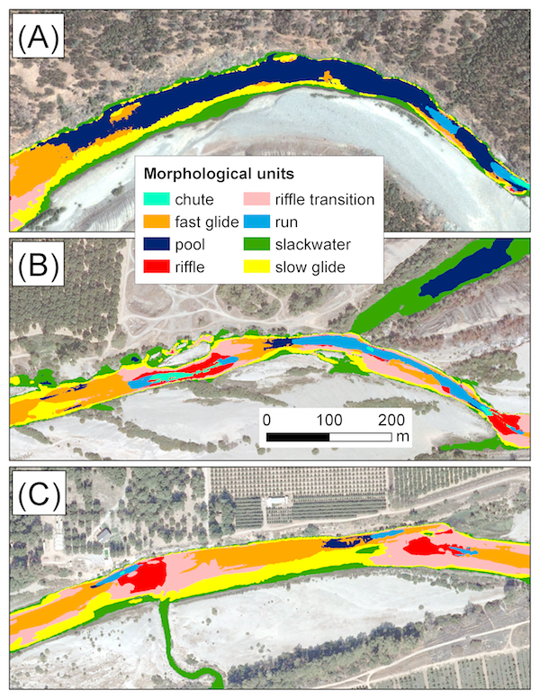
Sample 2DMU maps for a lowland cobble/gravel bed river

2DMU_LYR_example.png

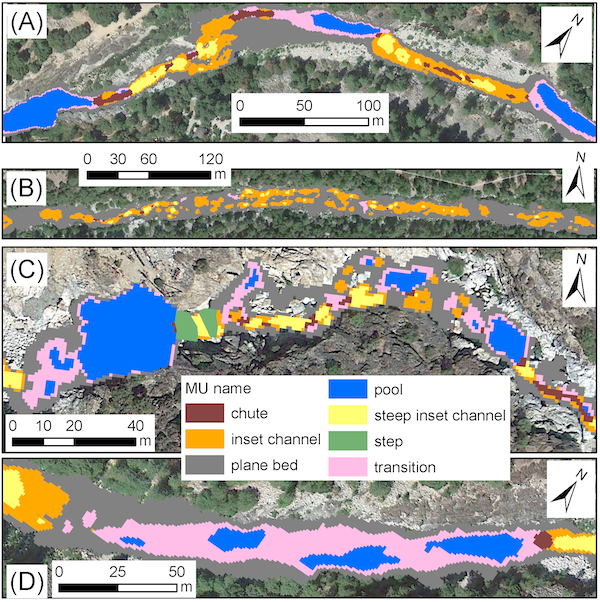
Sample 2DMU maps from a mountain bedrock/boulder controlled river

2DMU_SYRexample.png

Publications

  • Pasternack, G. B. and Senter, A.E. 2011. 21st Century instream flow assessment framework for mountain streams. California Energy Commission, PIER. CEC-500-2013-059.
  • Pasternack, G. B. 2011. 2D Modeling and Ecohydraulic Analysis. Createspace: Seattle, WA.
  • Wyrick, J. R. and Pasternack, G. B. 2012. Landforms of the Lower Yuba River.  Prepared for the Yuba Accord River Management Team. University of California at Davis, Davis, CA, 91pp.
  • Wyrick, J.R., Pasternack, G.B. 2014. Revealing the natural complexity of fluvial morphology through 2D hydrodynamic delineation of river landforms. Geomorphology 210: 14-22. http://dx.doi.org/10.1016/j.geomorph.2013.12.013
  • Wyrick, J.R., Pasternack, G.B. 2014. Geospatial organization of fluvial landforms in a gravel–cobble river: Beyond the riffle–pool couplet. Geomorphology 213: 48-65. http://dx.doi.org/10.1016/j.geomorph.2013.12.040
>2DMUs
  • Home
  • About Me
  • Research
    • Scientific Highlights
    • Projects
      • Near-Census River Science
        • 2DMUs
        • Hydraulic Topography
        • Topographic Change Detection
        • Topographic Change Processes
        • Floodplain Inundation
        • Streamwood Storage
        • Upper South Yuba
        • Salmonid Migration
        • North Yuba River
        • Salmon Migratory Habitat
      • Geomorphic Covariance Structures
      • Synthetic River Valleys
      • Watershed Processes
        • Watershed Sediment Transport
        • Watershed Streamwood
        • Watershed Sedimentation
      • River Rehabilitation
        • Spawning Habitat Rehabilitation
        • Cobble/Gravel Injection
        • Streamwood Jams
        • Geomorphologist's Guide
      • Waterfalls
        • Horseshoe Falls
        • NSEAM 1.0
        • Hydraulic Jumps
        • Small Step Mapping
        • Small Step Hydraulics
      • Tidal Freshwater Deltas
        • TFD Introduction
        • TFD Vegetation
        • TFD Sediment Cycles
        • TFD Ecogeomorphology
        • TFD Hydrometeorology
        • TFD Sediment Transport
        • TFD Modeling
        • TFD Animal Response
        • Bush River, MD
        • Winter's Run, MD
      • Estuarine Processes
        • Salinas River Estuary
        • San Joaquin-Sacramento Delta
        • Blackwater National Wildlife Refuge
        • Long Island Sound
      • Functional Flows Model
      • Volcanic Lakes
        • VL Classification & Modeling
        • VL Bibliography
        • Keli Mutu
          • Remote Sampling Strategy
        • Lake Batur
        • Other Volcanic Lakes
      • Agricultural Sediment
      • Urban Rivers
      • Chaos in Hydrology
      • Channel Types
    • Methods
      • Net Sedimentation Tile (NST) Protocol
      • Sediment Core Processing Protocol
      • Vibracoring Protocol
      • Loss-On-Ignition Protocol
      • C-14 Sample Selection and Prep Protocol
      • Cation Sample Prep and Analysis Protocol
      • Grain Size Distirbution Protocol
      • MS Word Fig. code
      • Kite Blimp Method
      • Laser Granulometer Protocol
    • Software
      • River Builder
    • Sponsors
  • Teaching
    • SAS 004Y : Water in Popular Culture
      • Course Logistics
      • Sections
      • Syllabus
        • SAS004 Introduction
        • Water Scarcity
        • Water Scarcity Discussion
        • Floods
        • Flood Insurance Discussion
        • Water Quality
        • Water Quality Discussion
        • Water & Psychology
        • Water Psychology Discussion
        • Conquering Nature
        • Conquering Nature Discussion
        • Pro Poor Water
        • Pro Poor Water Discussion
        • Arctic Socio-Ecology
        • Indigenous Knowledge
        • Earth Stewardship
        • Earth Stewardship Discussion
        • Global Climate Change
        • Global Climate Change Discussion
        • Coastal Zone in Crisis
        • Coastal Zone Crisis Discussion
        • Course Review
      • Readings
      • Instructor
      • Classroom Behavior
      • Grading Policy
      • Movie Logs
      • Discussion Activities
      • Expository Essay
      • Study Guide
      • Online TA Help
    • ESM 125: River Conservation
      • Syllabus
        • River Conservation Introduction
        • Navigability For Title - Law
        • River Segmentation
        • Historical Hydrology
        • Indigenous River Conservation
        • Habitat Conservation Law
        • Aquatic Habitat
        • Riparian Habitat
        • Water Temperature
        • Sediment Sampling
        • Water Quality
        • CA State Water Boards
        • Biological Opinions
        • Setting Biological Goals
        • County-Level Water Management
        • River Restoration
        • Fish Passage & Fishways
        • Beaver-Assisted Restoration
        • Water Management Lessons
      • Instructor
      • Grading Policy
      • Readings
      • Exams
      • Individual Assignments
      • River Presentations
      • Video Response Canvas Quizzes
      • Reading Response Canvas Quizzes
    • HYD 143 : Ecohydrology
      • Instructor
      • Grading Policy
      • Syllabus
        • Chapter 1
        • Chapter 2
        • Chapter 3
        • Chapter 4
        • Chapter 5
        • Group Activity 1
        • Group Presentations 1
        • Chapter 6
        • Chapter 7
        • Chapter 8
        • Chapter 9
        • Group Activity 2
        • Group Presentations 2
        • Chapter 10
        • Chapter 11
        • Chapter 12
        • Chapter 13
        • Chapter 14
        • Chapter 15
        • Group Activity 3
        • Group Presentations 3
        • Chapter 16
        • Chapter 17
        • Chapter 18
        • Chapter 19
        • Chapter 20
        • Chapter 21
      • Online TA Help
      • Video Response Quizzes
      • Group Presentations
      • In-class Assignments
    • HYD 151 : Field Methods in Hydrology
      • Instructor
      • TA Info
      • Grading Policy
      • Syllabus
        • Chapter 21
        • Chapter 1
        • Chapter 2
        • Chapter 3
        • Chapter 4
        • Assignment 1
        • Chapter 5
        • Chapter 6
        • Assignment 2
        • Chapter 7
        • Chapter 8
        • Chapter 9
        • Assignment 3
        • Chapter 10
        • Chapter 12
        • Chapter 11
        • Chapter 13
        • Chapter 14
        • Assignment 4
        • Chapter 15
        • Chapter 16
        • Chapter 16b
        • Chapter 17
        • Field Equipment Showcase
        • Chapter 18
        • Chapter 19
        • Chapter 20
        • Chapter 22
        • Chapter 23
        • Chapter 24
        • Course Review
      • Readings
      • Online TA Help
      • Field Safety
    • HYD 252: Hillslope Geomorphology and Sediment Budgets
      • Instructor
      • Grading Policy
      • Syllabus
        • Week 1
        • Week 2
        • Week 3
        • Week 5
        • Week 6
        • Week 7
        • Week 8
        • Week 9
        • Week 10
        • Week 4
      • Readings
      • Safety
    • HYD 254Y: Ecohydraulics
      • Instructor
      • Grading Policy
      • Syllabus
        • Introduction to Near-Census River Science
        • Introduction to 2D Modeling
        • 2D Modeling Training
        • 2D modeling discussion & synthesis
        • 2D Modeling Terrain Variability
        • 2D Model Validation
        • Fluvial Landform Assessment
        • Ecological Analysis of Structure and Function
        • Hydrogeomorphic Processes
        • Parameterizing Boundary Roughness
        • Frontiers of River Science
      • Readings
      • Online TA Help
      • Lab Tutorials
    • HYD 256: Geomorphology of Estuaries and Deltas
      • Syllabus
        • Week 1
        • Week 2
        • Week 3
        • Week 4
        • Week 5
        • Week 6
        • Week 7
        • Week 8
        • Week 9
        • Week 10
      • Readings
      • Lab
      • Field Safety
      • Online TA Help
      • Grading Policy
    • Virtual River Methods
      • Syllabus
      • Instructor
      • Grading Policy
      • Readings
      • Assignments
      • Game Setup
  • People
    • MS Students
    • PhD Students
    • Postdocs
    • Committee Advisees
    • Technicians
    • Undergrads
    • Visitors
    • Collaborators
    • Furry Friends
  • Info for Applicants
  • Service
    • Past Service
    • Professional Service
  • Outreach
  • Curriculum Vitae

GET IN TOUCH

  • 223 Veihmeyer Hall
    LAWR Dept., UC Davis
    One Shields Avenue
    Davis, CA 95616
  • (530) 302-5658
  • (530) 752-1552
  • gpast@ucdavis.edu
  • Google Scholar
  • Research Gate
  • ORCID: 0000-0002-1977-4175
  • Dr. Gregory B. Pasternack - Watershed Hydrology, Geomorphology, and Ecohydraulics
UC Davis