>NSEAM 1.0
Home » Research » Projects » Waterfalls » NSEAM 1.0

NSEAM 1.0

Channel Configuration Control on Energy Dissipation and Hydraulic Jump Regime at River Steps

Participants

Gregory B. Pasternack and Joshua R. Wyrick

Background

The river step is an important driver for geomorphic evolution in bedrock rivers, but the effect that variations in channel geometry upstream and downstream of a river step have on hydraulic jump regime and energy dissipation has not previously been investigated. The associated hydraulic jump is inherent to a river step and its regime is a primary control on step morphodynamics. In turn, the hydraulic jump regime is controlled by several variables as detailed in a new conceptual framework developed in this study.

Step Conceptual Framework

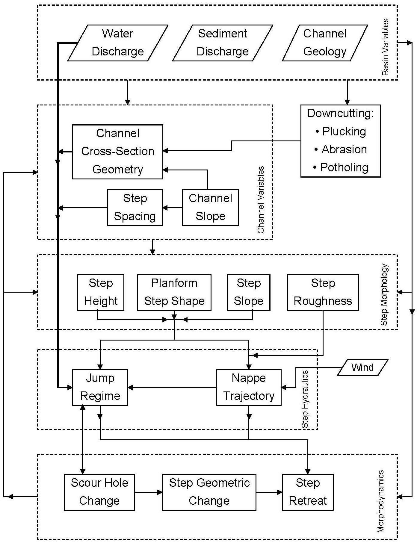
The role of hydraulic jump regime in scour at the bottom of a river step is not widely understood. Very few experimental studies of river steps have varied the hydraulic jump regime over the full range possible to explore this factor. To promote a better understanding of the general relevance of hydraulic jumps associated with river steps for water resources management and to guide research ultimately leading to prediction of river step morphodynamics, a conceptual model encompassing independent variables and responding processes was developed in which the key dynamics were grouped into five categories (see figure below). Evolution of a river step can be characterized by the processes of scour hole formation, upstream retreat, and change in step geometry. These processes are driven by a complex, interdependent set of hydrologic and geologic variables acting over multiple scales. Basin variables include the independent watershed inputs of water and sediment discharges as well as channel geology (see figure below). For example, some steps may exist in various geologic conditions ranging from well-bedded sedimentary bedrock to fractured homogeneous igneous bedrock. The role of sediment supply has been an important recent addition to shear stress models [e.g., Sklar and Dietrich, 2004; Gasparini et al., 2007]. The basin variables control the channel variables, which include the cross-sectional geometries within the channel, the channel slope, and the longitudinal spacing between river steps. In this framework, a sequence of cross sections is used as an indicator of complex 3-D channel morphology, since channel width and cross-sectional area often fluctuate down a mountain river system, even as they generally increase downstream because of increasing discharge. Basin variables also help shape the step morphology components of step height, planform shape of the step, step slope, and step roughness. Step height can be dependent upon step spacing [Wohl and Grodek, 1994].

All of the step morphology variables affect step hydraulics characterized by the nappe trajectory and hydraulic jump regime, though step roughness only affects the jump regime indirectly through nappe trajectory. Nappe trajectory and hydraulic jump regime are of central importance in the conceptual model because (1) the former is a key variable controlling jet scour of bedrock near the step toe [Mason and Arumugam, 1985; Bormann and Julien, 1991; Stein et al., 1993; Alonso et al., 2002], where toe refers to the slope break at the bottom of the step and (2) the latter controls turbulent lift forces that pluck and suspend bedrock downstream of the point of jet impact [Fiorotto and Rinaldo, 1992; Pasternack et al., 2007]. Nappe trajectories for linear overfalls have been thoroughly investigated [U.S. Bureau of Reclamation, 1948b; Vischer and Hager, 1998; Chanson, 2002], while those for overfalls with 3-D brink configurations have only recently come under some scrutiny [Falvey, 2003; Pasternack et al., 2006]. Hydraulic jump regimes for a free overfall include: supercritical flow with no jump, pushed-off unsubmerged jump (defined later in section 2.4), optimal jump, submerged jump, standing waves, and subcritical flow with no jump [U.S. Bureau of Reclamation, 1948b; Leutheusser and Birk, 1991]. Hydraulic jump regime is strongly influenced by discharge and tailwater depth [U.S. Bureau of Reclamation, 1948b; Pasternack et al., 2006], with the latter in turn controlled by upstream and downstream channel configuration. Step brink planform shapes that deviate from linearity cause nappe interference and a shift in jump regime for a given discharge and channel configuration [Falvey, 2003; Pasternack et al., 2006]. Additionally, the nappe regime has been anecdotally observed to be affected by the direction and magnitude of wind impacting it, but no scientific studies have yet explored nappe response to diverse wind regimes.

Step hydraulics such as jet impact, turbulent pressure fluctuations, drag, and lift drive channel morphodynamics by changing the size and shape of the scour hole [Lenzi et al., 2003; Alonso et al., 2002], step geometry [Pasternack et al., 2006], and upstream retreat of the step [Hanson et al., 1997; Bennett et al., 2000; Stein and LaTray, 2002]. Upstream retreat is determined by the relative erodibility and erosional force on the step top versus that on the face and toe of the step [e.g., Stein and Julien, 1993; Flores- Cervantes et al., 2006; Frankel et al., 2007]. The shape of the scour hole and the regime of the associated hydraulic  jump affect the erosional ability of the flow below the step. Scour depth has previously been shown to be dependent on step morphology [Alexandrowicz, 1994; Lenzi et al., 2002] and sediment supply [e.g., Marion et al., 2006]. Step morphodynamics, in turn, can affect channel geometry and step morphology.

The conceptual framework described above serves to organize past research, promote quantification of identified linkages, and highlight important gaps in the current understanding. A casual observer of major waterfalls and whitewater rapids in mountain rivers will quickly take note of the diversity and complexity of natural step morphologies. Addressing natural diversity presents the most important gap in the scientific understanding of river steps. This study addresses the problem of how channel expansions and constrictions through geomorphic units with steps affect step fluid mechanics.

Stepmodel_fig01.jpg

NSEAM 1.0 

Wyrick and Pasternack (2008) described a new parsimonious semi-analytical numerical model of step hydraulics to quantify energy dissipation and delineate hydraulic jump regimes, accounting for discharge, jump submergence, and non-uniform channel geometry through a step. This model is called the Nonuniform Step Energy Analysis Model (NSEAM), version 1.0. Despite remaining limitations in step theory, NSEAM simulates how natural steps respond to a wide range of conditions. The model shows that hydraulic jump regime and energy dissipation exhibit greater sensitivity to channel non-uniformity as discharge increases and/or step height decreases. Also, channel conditions that create greater jump submergence lead to decreased energy dissipation, regardless of the discharge regime. The model also reinforces the common observation about gully erosion that downstream channel widening enhances upstream knickpoint migration. The new algorithm may be used to aid river engineering involving steps and could be useful for landscape evolution modeling.

NSEAM 1.0 is presently implemented in Mathematica and in Excel versions, but only the Excel version is polished for public distribution.

CLICK HERE TO DOWNLOAD NSEAM 1.0

Publication

Wyrick, J. R. and Pasternack, G. B. 2008. Modeling energy dissipation and hydraulic jump regime responses to channel nonuniformity at river steps. Journal of Geophysical Research 113, F03003, doi:10.1029/2007JF000873.

>NSEAM 1.0
  • Home
  • About Me
  • Research
    • Scientific Highlights
    • Projects
      • Near-Census River Science
        • 2DMUs
        • Hydraulic Topography
        • Topographic Change Detection
        • Topographic Change Processes
        • Floodplain Inundation
        • Streamwood Storage
        • Upper South Yuba
        • Salmonid Migration
        • North Yuba River
        • Salmon Migratory Habitat
      • Geomorphic Covariance Structures
      • Synthetic River Valleys
      • Watershed Processes
        • Watershed Sediment Transport
        • Watershed Streamwood
        • Watershed Sedimentation
      • River Rehabilitation
        • Spawning Habitat Rehabilitation
        • Cobble/Gravel Injection
        • Streamwood Jams
        • Geomorphologist's Guide
      • Waterfalls
        • Horseshoe Falls
        • NSEAM 1.0
        • Hydraulic Jumps
        • Small Step Mapping
        • Small Step Hydraulics
      • Tidal Freshwater Deltas
        • TFD Introduction
        • TFD Vegetation
        • TFD Sediment Cycles
        • TFD Ecogeomorphology
        • TFD Hydrometeorology
        • TFD Sediment Transport
        • TFD Modeling
        • TFD Animal Response
        • Bush River, MD
        • Winter's Run, MD
      • Estuarine Processes
        • Salinas River Estuary
        • San Joaquin-Sacramento Delta
        • Blackwater National Wildlife Refuge
        • Long Island Sound
      • Functional Flows Model
      • Volcanic Lakes
        • VL Classification & Modeling
        • VL Bibliography
        • Keli Mutu
          • Remote Sampling Strategy
        • Lake Batur
        • Other Volcanic Lakes
      • Agricultural Sediment
      • Urban Rivers
      • Chaos in Hydrology
      • Channel Types
    • Methods
      • Net Sedimentation Tile (NST) Protocol
      • Sediment Core Processing Protocol
      • Vibracoring Protocol
      • Loss-On-Ignition Protocol
      • C-14 Sample Selection and Prep Protocol
      • Cation Sample Prep and Analysis Protocol
      • Grain Size Distirbution Protocol
      • MS Word Fig. code
      • Kite Blimp Method
      • Laser Granulometer Protocol
    • Software
      • River Builder
    • Sponsors
  • Teaching
    • SAS 004Y : Water in Popular Culture
      • Course Logistics
      • Sections
      • Syllabus
        • SAS004 Introduction
        • Water Scarcity
        • Water Scarcity Discussion
        • Floods
        • Flood Insurance Discussion
        • Water Quality
        • Water Quality Discussion
        • Water & Psychology
        • Water Psychology Discussion
        • Conquering Nature
        • Conquering Nature Discussion
        • Pro Poor Water
        • Pro Poor Water Discussion
        • Arctic Socio-Ecology
        • Indigenous Knowledge
        • Earth Stewardship
        • Earth Stewardship Discussion
        • Global Climate Change
        • Global Climate Change Discussion
        • Coastal Zone in Crisis
        • Coastal Zone Crisis Discussion
        • Course Review
      • Readings
      • Instructor
      • Classroom Behavior
      • Grading Policy
      • Movie Logs
      • Discussion Activities
      • Expository Essay
      • Study Guide
      • Online TA Help
    • ESM 125: River Conservation
      • Syllabus
        • River Conservation Introduction
        • Navigability For Title - Law
        • River Segmentation
        • Historical Hydrology
        • Indigenous River Conservation
        • Habitat Conservation Law
        • Aquatic Habitat
        • Riparian Habitat
        • Water Temperature
        • Sediment Sampling
        • Water Quality
        • CA State Water Boards
        • Biological Opinions
        • Setting Biological Goals
        • County-Level Water Management
        • River Restoration
        • Fish Passage & Fishways
        • Beaver-Assisted Restoration
        • Water Management Lessons
      • Instructor
      • Grading Policy
      • Readings
      • Exams
      • Individual Assignments
      • River Presentations
      • Video Response Canvas Quizzes
      • Reading Response Canvas Quizzes
    • HYD 143 : Ecohydrology
      • Instructor
      • Grading Policy
      • Syllabus
        • Chapter 1
        • Chapter 2
        • Chapter 3
        • Chapter 4
        • Chapter 5
        • Group Activity 1
        • Group Presentations 1
        • Chapter 6
        • Chapter 7
        • Chapter 8
        • Chapter 9
        • Group Activity 2
        • Group Presentations 2
        • Chapter 10
        • Chapter 11
        • Chapter 12
        • Chapter 13
        • Chapter 14
        • Chapter 15
        • Group Activity 3
        • Group Presentations 3
        • Chapter 16
        • Chapter 17
        • Chapter 18
        • Chapter 19
        • Chapter 20
        • Chapter 21
      • Online TA Help
      • Video Response Quizzes
      • Group Presentations
      • In-class Assignments
    • HYD 151 : Field Methods in Hydrology
      • Instructor
      • TA Info
      • Grading Policy
      • Syllabus
        • Chapter 21
        • Chapter 1
        • Chapter 2
        • Chapter 3
        • Chapter 4
        • Assignment 1
        • Chapter 5
        • Chapter 6
        • Assignment 2
        • Chapter 7
        • Chapter 8
        • Chapter 9
        • Assignment 3
        • Chapter 10
        • Chapter 12
        • Chapter 11
        • Chapter 13
        • Chapter 14
        • Assignment 4
        • Chapter 15
        • Chapter 16
        • Chapter 16b
        • Chapter 17
        • Field Equipment Showcase
        • Chapter 18
        • Chapter 19
        • Chapter 20
        • Chapter 22
        • Chapter 23
        • Chapter 24
        • Course Review
      • Readings
      • Online TA Help
      • Field Safety
    • HYD 252: Hillslope Geomorphology and Sediment Budgets
      • Instructor
      • Grading Policy
      • Syllabus
        • Week 1
        • Week 2
        • Week 3
        • Week 5
        • Week 6
        • Week 7
        • Week 8
        • Week 9
        • Week 10
        • Week 4
      • Readings
      • Safety
    • HYD 254Y: Ecohydraulics
      • Instructor
      • Grading Policy
      • Syllabus
        • Introduction to Near-Census River Science
        • Introduction to 2D Modeling
        • 2D Modeling Training
        • 2D modeling discussion & synthesis
        • 2D Modeling Terrain Variability
        • 2D Model Validation
        • Fluvial Landform Assessment
        • Ecological Analysis of Structure and Function
        • Hydrogeomorphic Processes
        • Parameterizing Boundary Roughness
        • Frontiers of River Science
      • Readings
      • Online TA Help
      • Lab Tutorials
    • HYD 256: Geomorphology of Estuaries and Deltas
      • Syllabus
        • Week 1
        • Week 2
        • Week 3
        • Week 4
        • Week 5
        • Week 6
        • Week 7
        • Week 8
        • Week 9
        • Week 10
      • Readings
      • Lab
      • Field Safety
      • Online TA Help
      • Grading Policy
    • Virtual River Methods
      • Syllabus
      • Instructor
      • Grading Policy
      • Readings
      • Assignments
      • Game Setup
  • People
    • MS Students
    • PhD Students
    • Postdocs
    • Committee Advisees
    • Technicians
    • Undergrads
    • Visitors
    • Collaborators
    • Furry Friends
  • Info for Applicants
  • Service
    • Past Service
    • Professional Service
  • Outreach
  • Curriculum Vitae

GET IN TOUCH

  • 223 Veihmeyer Hall
    LAWR Dept., UC Davis
    One Shields Avenue
    Davis, CA 95616
  • (530) 302-5658
  • (530) 752-1552
  • gpast@ucdavis.edu
  • Google Scholar
  • Research Gate
  • ORCID: 0000-0002-1977-4175
  • Dr. Gregory B. Pasternack - Watershed Hydrology, Geomorphology, and Ecohydraulics
UC Davis