Keli Mutu
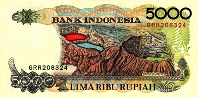
(Image of the Keli Mutu lakes from the Indonesian 5,000 Rupiah bill)
Indonesian setting
Indonesia is one of the world's most geologically active countries. Given its combination of active volcanism and tropical climate, it is home to several volcanoes which exemplify the type of dynamic interactions between the forces of the endosphere and exosphere that are characteristic of volcanic lake environments. Of all the volcanos in Indonesia, Keli Mutu on the island of Flores appears to have the most exotic lakes. In fact, its lakes are so brightly colored that they are featured on the 5,000 rupiah bill and thought of as a national treasure by the people of Indonesia.
Located between Malaysia and Australia, the islands comprising the approximately 3,000 mile long latitudinal axis of Indonesia are the physical expression of the subduction of the Indo-Australian plate to the south beneath the Eurasian plate to the north. Typical features of such "island arcs" are andesitic stratovolcanoes. These volcanoes may either be 1) well-developed lofty cones (e.g. Merapi in central Java) or 2) complex structures featuring mutiple craters and irregular moonscape summits sculpted by alternate periods of building up and destruction (e.g. Una-Una in Celebes) (Umbgrove, 1949). The active stratovolcanoes of Indonesia are particularly well known for their highly explosive eruptions, devastating lahars (mud-flows), and associated tsunami waves. Currently there are more than 200 active and many more extinct volcanoes present in Indonesia.
Because Indonesia straddles the equator it does not have temperature-defined seasons. The year-round average monthly temperature is ~80 deg F and the average rainfall is ~3 m/year (Ulack & Pauer, 1989). Those islands that deviate to the north or south of the equator may experience monsoons, while those that are closer to Australia are subject to a more pronounced dry season. Where present, the dry season spans from August through part of October and is immediately followed by a wet season that eventually winds down in March. Striking seasonal variations in precipitation along the latitudinal axis of Indonesia were first described by the naturalist George Wallace (co-founder of the theory of evolution by natural selection) in the mid 1800's.
Keli Mutu Setting
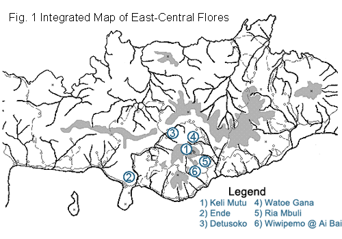
Keli Mutu is a passively degassing stratovolcano (Fig.1) capped by three crater lakes (Fig. 2) containing exotic fluids and whose physico-chemical expressions have changed dramatically through the years. The volcano is located on Flores, an island along the Lesser Sunda islands chain of Indonesia. An early description of Keli Mutu was provided by the French naturalist LeRoux, who mentions it in his travel log of eastern Indonesia in 1896. A more comprehensive geologic and topographic survey was performed in the 1920's by the Dutch colonial geologist Kemmerling, who traveled through Flores on horseback and early motor vehicle. Since 1929 no publicly reported systematic survey of Flores has been done using modern techniques. A map of Flores (TPC N-12BG) was published in 1972 as part of the World Aeronautical Chart (WAC) series, but the topographic information is sketchy.
Keli Mutu Crater Lakes
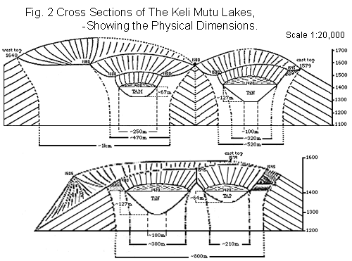
Three crater lakes are located on the eastern summit of Keli Mutu. Each of the lakes has a distinctive physical structure, a unique geochemical and hydrothermal regime, and a particular historical sequence of color changes controlled by changes in physico-chemical conditions.
Tiwu Ata Polo (TAP), the "enchanted lake", lies on the southeastern side of the volcanic peak (Fig.3). A thermal plume in the northwest part of the lake indicates underlying subaerial fumarolic or hydrothermal activity. A white froth is present on the lake's surface around the plume when the convective activity momentarily increases. Rock debris is often carried into TAP during rainstorms by water draining the volcano summit around the lake. Two peaks abutting the crater rim help stabilize the east and northeast crater wall, while further around to the southeast a dip suggests a possible one-time overflow outlet. Such an outlet would have fed the river Ria Mbuli, whose upland source is in that area.
|
|
|
Tiwu Nua Muri Koohi Fah (TiN), the "lake of young men and maidens", is adjacent to TAP and is the deepest lake (Fig.4). A sizable tear in the western wall was the location of a pre-1929 breaching and overflow event. Visible fumarolic activity above the shoreline of TiN was reported by Kemmerling, but this activity has declined and is no longer present. Subaerial fumarolic or hydrothermal activity is implied by a large thermal plume in the center of the lake which slowly convects the water. A fresh supply of yellow froth (probably the same type of elemental sulfur found in the "cool acid-brine" crater lake at Kawa Ijen) is brought up by the plume and pushed out toward the crater wall. A particularly large cover of this froth has accumulated at the base of the north wall (Fig.4). During rainstorms the froth is scattered by inflowing water and landslides, though some of it may be disappearing altogether.
TAP and TiN are only separated by a steep parabolic partition that arcs down to a minimum height of ~35m above the surface level of the lakes (Fig.3). According to Kemmerling this separating wall was as high as the surrounding crater rim 70 years before his survey, but it had subsequently eroded down by the time of his visit (Kemmerling, 1929). Recent unconfirmed reports (1996) state that the partition has crumbled and the lakes are now mingled. A directory of volcanoes published by the Smithsonain Institute lists moderate "hydrothermal blasts" of TiN that occured in 1938 and again in 1965. Each of these events was reported to have lasted longer than a month but was small and confined to the crater (Simkin et al, 1981).
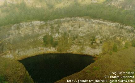
Tiwu Ata Mbupu (TAM), the "lake of elders", is the western-most lake (Fig. 5). TAM is structurally different from the other two in that the pit crater it is in is itself located in the center of a larger crater. Kemmerling reported both aerial and subaerial fumarolic activity for the TAM crater, but none was observed in 1992. Small landslides constantly add to the steep rubble slopes along the lake's shore, and large boulders periodically drop into the lake. TAM's shoreline is coated with a film colored in different shades of red, orange, and yellow depending on how thick it is. Gypsum crystals grow in the cracks of the crater wall in the first few meters above the prosent water surface.
Research at Keli Mutu
Geochemical surveys and subsequent analyses of the lakes on Keli Mutu have been carried out recently by scientists from Wesleyan University (Middletown, CT, USA). Results have been published in
-
- Pasternack, G.B. (1993) Acid-brine crater lakes: a case study. Undergraduate senior thesis, Wesleyan University, 160 pp.
Pasternack, G.B. and Varekamp, J.C. (1994) The geochemistry of the Keli Mutu crater lakes, Flores, Indonesia, Geochemical Journal 28:243-262.
reprint requests to: gpast@ucdavis.edu.
The work involved describing the chemistry of each lake, interpreting the chemistries in terms of water-rock interactions and volcanic fluxes, and deriving a physical lake model that delineates the parameter-window for volcanic crater lake existence.
Geochemical investigation of the vertical and lateral compositions of the lakes on Keli Mutu required the use of a remote sampling system. Lake temperature, pH, and dissolved oxygen content were determined in the field, while the analytical chemistries of lake fluids and sediments were determined in the months after the expedition to Keli Mutu. To reconstruct the in situ chemistries of the lakes' aqueous systems, a solution equilibrium modeling program (SOLVEQ) was applied.
The primary conclusion of the work at Keli Mutu is that the three Keli Mutu lakes are all fed by a similar volcanic gas source, but as a result of the mediated subaqueous transport of that gas it yields different chemical "expressions" in each crater lake. Specific findings include the following:
- Tiwu Ata Polo (TAP) is an intermediate "acid-saline" volcanic crater lake whose frequent color changes are probably the direct result of changes in the oxidation state of the lake's water. TAP is intermediate in volcanic activity relative to the other Keli Mutu lakes.
- Tiwu Nua Moori Koohi Fah (TiN) is a "cool acid-brine" volcanic crater lake that contains exotic sulfur compounds and probably a host of copper-rich minerals in the sediments. Of the three Keli Mutu lakes, TiN is presently experiencing the greatest fumarolic input, which may include a flux of ~85 tonnes of sulfur dioxide per day (~55MW energy output).
- Tiwu Ata Mbupu (TAM) is an "acid-sulfate" volcanic crater lake whose gaseous input is presently very small relative to those for the other Keli Mutu lakes. In the 1970s it appears that TAM was much more active than it presently is.
- Comparison of the individual lakes with their respective historic chemistries demonstrates that they are all approaching chemical steady state.
- Several seepage outlets exist on and around Keli Mutu. The river Watu Gana bears a strong TAP fluid signature, but other hydrothermal waters show no crater lake signature at all.
Info for Keli Mutu Tourists
Many Indonesian guidebooks describe the vibrant colors of the Keli Mutu lakes as resulting from the minerals in the lakes. While this is partly correct, the most important determinant of color in the lakes is oxygen. Just like your blood, when the lake waters lack oxygen they look green (look at your wrist). Conversely, when they are rich in oxygen, they are a deep red to black. Obviously this is oversimplifying matters a little, but the point is that you should not be misled... Contrary to guidebook authors claims (which aim to increase drama, mystery, suspense, etc), scientists do in fact understand why the lakes looks like they do.
