>Geomorphic Covariance Structures
Home » Research » Projects » Geomorphic Covariance Structures

Geomorphic Covariance Structures

Participants

Gregory B. Pasternack, Dr. Rocko Brown, Dastagir Baig, Joni Gore, Matthew Weber, Anne Senter

Background

River scientists have long known that natural rivers are highly heterogeneous in their spatial structure and physical-biological linkages, but most analyses have taken a blind statistical approach to the problem, and this cannot explain the coherent organization to heterogeneity.  Certainly, using statistics to blindly explore and affirm that heterogeneity exists was important, but now we need to know exactly what those patterns are, why, and how they function. This cannot be achieved with exploratory statistics. Instead, analyses must show how variables relate to each other. Toward this end, we have invented the concept of a "geomorphic covariance structure".

Geomorphic Covariance Structures

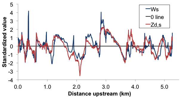
Many measurable variables in geomorphology and allied sciences vary along a pathway, such as a river corridor. Variables could be flow-independent measures of topography, sediment attributes, flow-dependent hydraulics, topographic change, and biotic variables. Rocko Brown coined the term "geomorphic covariance structure" (GCS) to mean the bivariate pattern of any two such variables. It is not the statistical covariance, which is a single number, but instead a new concept involving the complete bivariate spatial series form which a statistical covariance could be computed if desired. This project investigates the coherent patterns of all conceivable GCSs, beginning with those of physical variables in river corridors and moving on from there.

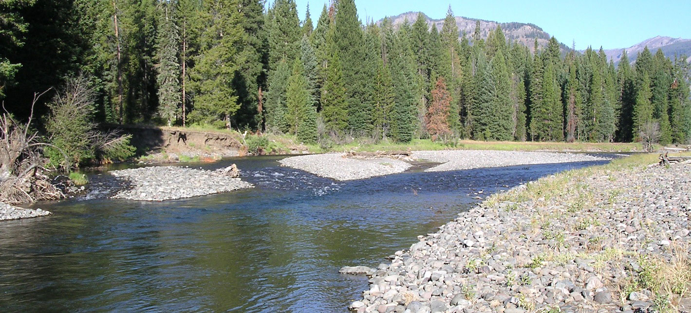
River Bed Elevation and Width GCS

The first GCS that we have looked into in great detail is that between river bed elevation and channel width. Many theories of how rivers function and practices for how rivers should be engineered for various purposes specific an explicit GCS between bed elevation and width.  Some require them to be "in phase" (i.e., high width and high bed elevation or the converse), while others require them to be "out of phase" (i.e., high width and low elevation). We have conducted several studies that analyze these patterns in real rivers and in natural channel designs.

 Ws_Zs_example.png

Links

None.

Publications

  • Brown, R. A., Pasternack, G. B. 2014. Hydrologic and topographic variability modulate channel change in mountain rivers. Journal of Hydrology 510: 551-564.
  • Brown, R. A., Pasternack, G. B., Lin, T. 2015. The topographic design of river channels for form-process linkages for river restoration. Environmental Management, 57 (4): 929-942. doi: 10.1007/s00267-015-0648-0.
  • Baig, D., Pasternack, G. B., Weber, M. D. 2016. The role of river corridor topographic variability in controlling hydraulic conveyance and geomorphic process as a function of discharge. American Association of Geographers Annual Meeting, San Francisco, Calif., 27 Mar to 2 Apr.
  • Gore, J., Pasternack, G. B. 2016. Analysis and classification of topographic flow steering and inferred geomorphic processes as a function of discharge in a mountain river. Abstract EP53D-1016 presented at 2016 Fall Meeting, AGU, San Francisco, Calif., 12-16 Dec.
  • Brown, R. A., Pasternack, G. B. 2017. Bed and width oscillations form coherent patterns in a partially confined, regulated gravel–cobble-bedded river adjusting to anthropogenic disturbances, Earth Surface Dynamics, 5, 1-20, doi:10.5194/esurf-5-1-2017.
>Geomorphic Covariance Structures
  • Home
  • About Me
  • Research
    • Scientific Highlights
    • Projects
      • Near-Census River Science
        • 2DMUs
        • Hydraulic Topography
        • Topographic Change Detection
        • Topographic Change Processes
        • Floodplain Inundation
        • Streamwood Storage
        • Upper South Yuba
        • Salmonid Migration
        • North Yuba River
        • Salmon Migratory Habitat
      • Geomorphic Covariance Structures
      • Synthetic River Valleys
      • Watershed Processes
        • Watershed Sediment Transport
        • Watershed Streamwood
        • Watershed Sedimentation
      • River Rehabilitation
        • Spawning Habitat Rehabilitation
        • Cobble/Gravel Injection
        • Streamwood Jams
        • Geomorphologist's Guide
      • Waterfalls
        • Horseshoe Falls
        • NSEAM 1.0
        • Hydraulic Jumps
        • Small Step Mapping
        • Small Step Hydraulics
      • Tidal Freshwater Deltas
        • TFD Introduction
        • TFD Vegetation
        • TFD Sediment Cycles
        • TFD Ecogeomorphology
        • TFD Hydrometeorology
        • TFD Sediment Transport
        • TFD Modeling
        • TFD Animal Response
        • Bush River, MD
        • Winter's Run, MD
      • Estuarine Processes
        • Salinas River Estuary
        • San Joaquin-Sacramento Delta
        • Blackwater National Wildlife Refuge
        • Long Island Sound
      • Functional Flows Model
      • Volcanic Lakes
        • VL Classification & Modeling
        • VL Bibliography
        • Keli Mutu
          • Remote Sampling Strategy
        • Lake Batur
        • Other Volcanic Lakes
      • Agricultural Sediment
      • Urban Rivers
      • Chaos in Hydrology
      • Channel Types
    • Methods
      • Net Sedimentation Tile (NST) Protocol
      • Sediment Core Processing Protocol
      • Vibracoring Protocol
      • Loss-On-Ignition Protocol
      • C-14 Sample Selection and Prep Protocol
      • Cation Sample Prep and Analysis Protocol
      • Grain Size Distirbution Protocol
      • MS Word Fig. code
      • Kite Blimp Method
      • Laser Granulometer Protocol
    • Software
      • River Builder
    • Sponsors
  • Teaching
    • SAS 004Y : Water in Popular Culture
      • Course Logistics
      • Sections
      • Syllabus
        • SAS004 Introduction
        • Water Scarcity
        • Water Scarcity Discussion
        • Floods
        • Flood Insurance Discussion
        • Water Quality
        • Water Quality Discussion
        • Water & Psychology
        • Water Psychology Discussion
        • Conquering Nature
        • Conquering Nature Discussion
        • Pro Poor Water
        • Pro Poor Water Discussion
        • Arctic Socio-Ecology
        • Indigenous Knowledge
        • Earth Stewardship
        • Earth Stewardship Discussion
        • Global Climate Change
        • Global Climate Change Discussion
        • Coastal Zone in Crisis
        • Coastal Zone Crisis Discussion
        • Course Review
      • Readings
      • Instructor
      • Classroom Behavior
      • Grading Policy
      • Movie Logs
      • Discussion Activities
      • Expository Essay
      • Study Guide
      • Online TA Help
    • ESM 125: River Conservation
      • Syllabus
        • River Conservation Introduction
        • Navigability For Title - Law
        • River Segmentation
        • Historical Hydrology
        • Indigenous River Conservation
        • Habitat Conservation Law
        • Aquatic Habitat
        • Riparian Habitat
        • Water Temperature
        • Sediment Sampling
        • Water Quality
        • CA State Water Boards
        • Biological Opinions
        • Setting Biological Goals
        • County-Level Water Management
        • River Restoration
        • Fish Passage & Fishways
        • Beaver-Assisted Restoration
        • Water Management Lessons
      • Instructor
      • Grading Policy
      • Readings
      • Exams
      • Individual Assignments
      • River Presentations
      • Video Response Canvas Quizzes
      • Reading Response Canvas Quizzes
    • HYD 143 : Ecohydrology
      • Instructor
      • Grading Policy
      • Syllabus
        • Chapter 1
        • Chapter 2
        • Chapter 3
        • Chapter 4
        • Chapter 5
        • Group Activity 1
        • Group Presentations 1
        • Chapter 6
        • Chapter 7
        • Chapter 8
        • Chapter 9
        • Group Activity 2
        • Group Presentations 2
        • Chapter 10
        • Chapter 11
        • Chapter 12
        • Chapter 13
        • Chapter 14
        • Chapter 15
        • Group Activity 3
        • Group Presentations 3
        • Chapter 16
        • Chapter 17
        • Chapter 18
        • Chapter 19
        • Chapter 20
        • Chapter 21
      • Online TA Help
      • Video Response Quizzes
      • Group Presentations
      • In-class Assignments
    • HYD 151 : Field Methods in Hydrology
      • Instructor
      • TA Info
      • Grading Policy
      • Syllabus
        • Chapter 21
        • Chapter 1
        • Chapter 2
        • Chapter 3
        • Chapter 4
        • Assignment 1
        • Chapter 5
        • Chapter 6
        • Assignment 2
        • Chapter 7
        • Chapter 8
        • Chapter 9
        • Assignment 3
        • Chapter 10
        • Chapter 12
        • Chapter 11
        • Chapter 13
        • Chapter 14
        • Assignment 4
        • Chapter 15
        • Chapter 16
        • Chapter 16b
        • Chapter 17
        • Field Equipment Showcase
        • Chapter 18
        • Chapter 19
        • Chapter 20
        • Chapter 22
        • Chapter 23
        • Chapter 24
        • Course Review
      • Readings
      • Online TA Help
      • Field Safety
    • HYD 252: Hillslope Geomorphology and Sediment Budgets
      • Instructor
      • Grading Policy
      • Syllabus
        • Week 1
        • Week 2
        • Week 3
        • Week 5
        • Week 6
        • Week 7
        • Week 8
        • Week 9
        • Week 10
        • Week 4
      • Readings
      • Safety
    • HYD 254Y: Ecohydraulics
      • Instructor
      • Grading Policy
      • Syllabus
        • Introduction to Near-Census River Science
        • Introduction to 2D Modeling
        • 2D Modeling Training
        • 2D modeling discussion & synthesis
        • 2D Modeling Terrain Variability
        • 2D Model Validation
        • Fluvial Landform Assessment
        • Ecological Analysis of Structure and Function
        • Hydrogeomorphic Processes
        • Parameterizing Boundary Roughness
        • Frontiers of River Science
      • Readings
      • Online TA Help
      • Lab Tutorials
    • HYD 256: Geomorphology of Estuaries and Deltas
      • Syllabus
        • Week 1
        • Week 2
        • Week 3
        • Week 4
        • Week 5
        • Week 6
        • Week 7
        • Week 8
        • Week 9
        • Week 10
      • Readings
      • Lab
      • Field Safety
      • Online TA Help
      • Grading Policy
    • Virtual River Methods
      • Syllabus
      • Instructor
      • Grading Policy
      • Readings
      • Assignments
      • Game Setup
  • People
    • MS Students
    • PhD Students
    • Postdocs
    • Committee Advisees
    • Technicians
    • Undergrads
    • Visitors
    • Collaborators
    • Furry Friends
  • Info for Applicants
  • Service
    • Past Service
    • Professional Service
  • Outreach
  • Curriculum Vitae

GET IN TOUCH

  • 223 Veihmeyer Hall
    LAWR Dept., UC Davis
    One Shields Avenue
    Davis, CA 95616
  • (530) 302-5658
  • (530) 752-1552
  • gpast@ucdavis.edu
  • Google Scholar
  • Research Gate
  • ORCID: 0000-0002-1977-4175
  • Dr. Gregory B. Pasternack - Watershed Hydrology, Geomorphology, and Ecohydraulics
UC Davis