
California Natural River Types
Project Leaders
Gregory B. Pasternack, Colin F. Byrne, Hervé Guillon, Belize A. Lane, Samuel Sandoval-Solis
Cooperating Institutions
Field data collectionw as performed by multiple organizations, depending on the region. These included teams from UC Davis, Humboldt State University (now Cal Poly-Humboldt), CSU-Monterey Bay, UC Riverside, and Southern California Coastal Water Research Project (SCCWRP).
Background
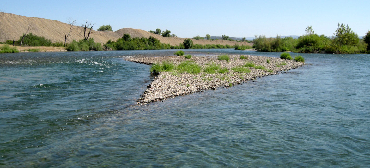
Management of river networks across entire catchments often proves difficult because rivers are often subjected to diverse of geologic, climatic, and topographic settings. The diversity of landscapes creates different geomorphic processes that lead to observable differences in river channel patterns, bedforms, and cross-sectional morphology. Classification of rivers allows scientists and practitioners to simplify highly complex systems into a more limited number of manageable channel types. Although classification of rivers can take place at various scales (e.g. morphological units), classification of river networks is often focused on the reach scale, or approximately 10 – 20 channel widths.
This project developed regional and statewide river classifications for California and then predicted the river type for every 200-m interval along the state's rivers (as mapped by the NHD+ dataset circa 2018) using machine learning modeling.
Study Area
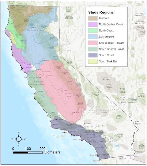
Per the map below, California is split into management basins with unique physiographic characteristics and management goals. Therefore, classifications are conducted for each of eight regions individually to provide more precise representation of stream types unique to different settings around the state
This research involved field work at 1,110 sites throughout the state of California to provide sufficient data to make regional and statewide data-driven classifications for the purpose of informing environmental flow strategies. Site selection was done using a novel, largely objecive procedure that involved a 4-way stratification of driving variables: sediment supply, physiography, local slope, and catchment area. Once all potential istes in a region were segregated that way, then individual sites were selected to achieve "equal effort" sampling of the diffeerent strata, with less concern about geogrpahic representation or randomness. California has rugged, extreme local settings such that a random dot anywhere on a map might take days to hike to, if accessible at all with field equipment. Random sampling was not important compared to representig the diversity of landforms arising from the different combinations of driving "genetic" variables. Therefore, field crews used maps of stratified geospatial data conditions to achieve equal-effort sampling using sites that were accessible.
Multivariate River Classification
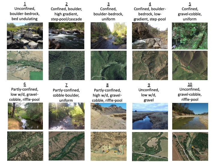
We implemented multivariate statistical techniques using a well-documented R-markdown coding approach to achieve data-driven classifications of rivers in each region. 200-m long sites were surveyed within each region to capture metrics that capture bankfull dimensions, dimensional variability, longitudinal profile, and sediment characteristics. In addition, sites were considered in relation to valley and basin-scale settings. Several bivariate and multivariate methods were coded into the R-markdown file to carefully analyze the data to determine the best approach to classifying rivers in each dataset. Survey sites were ultimately grouped based upon hierarchical clustering methods using carefully selected variables. Final river types were defined and described based on characterization of groups using median attributes of all sites within each group.
The image below shows one ecample, which is the Sacramento River catchment regional classification.
Machine Learning Stream Type Prediction
There are 689,029 stream intervals (200-m long) in the NHD+ streams dataset for California. We sampled 1,110 of them. Therefore, to have a product useful for setting expectations about environmental flows for any othe rlocaiton, it was necessary to use the observed sites in each region to train a machine learning model predict stream types in that region. This was accomplished and the resulting shapefile with predicted stream types is availabel upon request.
Links
Link to UC Davis eFlows website
Publications
Byrne, C. F., Guillon, H., Lane, B. A., Pasternack G. B., Sandoval-Solis, S. 2019. Sacramento River Basin Geomorphic Classification. Final Report. Prepared for the California State Water Resources Control Board. University of California, Davis, CA.
Byrne, C. F., Guillon, H., Lane, B. A., Pasternack G. B., Sandoval-Solis, S. 2020. Coastal California Regional Geomorphic Classification. Final Report. Prepared for the California State Water Resources Control Board. University of California, Davis, CA.
Byrne, C. F., Pasternack, G. B., Guillon, H., Lane, B. A., Sandoval-Solis, S.2020. Reach-scale bankfull channel types can exist independently of catchment hydrology. Earth Surface Processes and Landforms. DOI: 10.1002/esp.4874.
Byrne, C. F., Pasternack G. B., Guillon, H., Lane, B. A., Sandoval-Solis, S. 2021. Channel constriction predicts pool-riffle velocity reversals across landscapes. Geophysical Research Letters. DOI: 10.1029/2021GL094378.
Guillon, H., Byrne, C. F., Lane, B. A., Pasternack G. B., Sandoval-Solis, S. 2019. South fork of the Eel river Basin geomorphic Classification. Final Report. Prepared for the California State Water Resources Control Board. University of California, Davis, CA.
Guillon, H., Byrne, C. F., Lane, B. A., Sandoval-Solis, S., Pasternack G. B. 2020. Machine learning predicts reach-scale channel types from coarse-scale geospatial data in a large river basin. Water Resources Research 56 (3): e2019WR026691. DOI: 10.1029/2019WR026691.
Lane BA, Pasternack GB, Dahlke HE, Sandoval-Solis S. 2017. The role of topographic variability in river channel classification. Progress in Physical Geography : 0309133317718133. DOI: 10.1177/0309133317718133
Lane BA, Pasternack GB, Sandoval‐Solis S. 2018. Integrated analysis of flow, form, and function for river management and design testing. Ecohydrology DOI: 10.1002/eco.1969
Lane, B. A., Guillon, H., Byrne, C. F., Pasternack G. B., Kasprak, A., Sandoval-Solis, S. 2021. Channel-reach morphology and landscape properties are linked across a large heterogeneous region. Earth Surface Process and Landforms. DOI: 10.1002/esp.5246.
