>Synthetic River Valleys
Home » Research » Projects » Synthetic River Valleys

Synthetic River Valleys

Participants

Gregory B. Pasternack, Rocko A. Brown, Belize A. lane, Rafaeli O. Arroyo

Superseded

This content has been superceded by development of River Builder, but there are some good ideas and content on this page, so it is saved to provide some background and historical ocntext to River Builder development.

Background

There are two phases of knowledge production: analysis and synthesis.  During the analysis phase, scientists aim to explore nature and discern natural laws.  Near-census river science is a state-of-the-art approach to analyzing natural rivers at this time.  However, the history of science shows that scientists can end up satisfied with principles that are surprising crude with low explanatory power.  Without being forced to put scientific knowledge to the test in real-world applications, there is not sufficient necessity and pressure to insure that scientific ideas are accurate and complete.  That is why there needs to be a synthesis phase.  During synthesis, scientists collaborate with engineers and technologists to bring their ideas to practical application.  Applications may take place in a lab setting, in a computer program, or through real-world construction projects.

Synthetic River Valleys (SRVs)

In the Pasternack Lab we straddle analysis and synthesis to keep pushing ourselves onward using necessity as a driver for creative exploration. Synthetic river valleys (SRVs) is the most advanced scheme yet that we have developed to push synthesis of scientific ideas into practical solutions.  The concepts and methods underlying SRVs was spearheaded by Ph.D. candidate Rocko Brown. It has to do with designing entire river corridors with many degrees of freedom, taking advantage of some prescriptive scientific laws, but not bounded by them either.  Nature is an open system with surprising flexibility and dynamism.  Synthetic river valleys open the possibility of exploring a wide array of landscape possibilities for both scientific purposes as well as societal ones.  In a few case, SRVs have already been used to design river rehabilitation projects in collaboration with the private sector.  However, this is an active area of research that is still young and has a lot more possibilities to explore.

SRV Examples

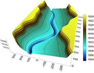
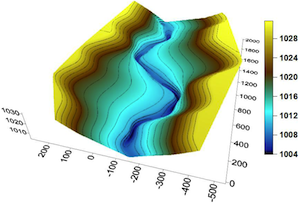
Below are two relatively simple "bare Earth" SRVs to illustrate what they can look like. These river valleys contain a bed slope, bed elevation undulation, channel width undulation, channel-cross section asymmetry, floodplain side slope, and undulating valley walls.  Several of the size, shape, and undulation variables are linked through geometric correlation structures, which are some of the underlying ways that landforms create organized, orderly spatial patterns.  There are many additional features that can be added to a river corridor to layer complexity and diversity on top of these basic structures.  What these exmaples reveal is that a relatively small number of linnked variables can generate quite distinct river corridors.

SRV_example1_300.png

SRV_example2_300.png

SRV Software Platforms

The underlying equations needed to make synthetic river valleys are already known, published, and non-proprietary. How those equations are organized into software is what is at issue here. At this time, there are three known implementations of SRVs into different software platforms.

First, an SRV generation "program" was developed using formulas in a Microsoft Excel® file, spanning multiple worksheets. This approach reproduces the examples in Brown et al. (2014). Rocko Brown has licensed this version of the software from UCD and has done some subsequent development. He calls his Excel SRV software “RiverSynth”. You should email him directly for the latest version made in Excel.

Second, using an unrestricted donation from a private foundation, UC Davis sponsored World Machine, LLC to incorporate SRVs into the World Machine platform on the hopes that this would make this methodology more accessible. World Machine (http://www.world-machine.com) is a native geometric modeling platform for digital terrain development that allows for precise specification of parameters to design diverse landscapes through dialogue boxes and flowcharting. Implementations of World Machine with river design capabilities are part of version 3 and later. They may not be available for free and may still be developmental, with little to no technical support. Be sure to touch base with World Machine, LLC to find out the current status of SRV tools in that platform as well as what support they offer to users to help learn their implementation of SRV tools and to address any bugs or problems that come up with your projects.

Finally, UC Davis has implemented SRVs into a free, publicly available source code in the software language R. This version is called "River Builder". It is available from CRAN at this link and explained more at the website provided next.

River Builder 1.0.0 Software Here

Link to River Builder website

On-going Research

We are continuing to make progress with our SRV algorithm and scope of studies.In one line of research we are investigating and coding more variability functions to expand the geometric modeling capabilities of the method. In another line of research we are building SRV archetypes for many different kinds of rivers in support of regional flow and habitat management. Finally, we are exploring ways to automate SRV design by drawing on landscape attributes at larger scales that help set the local features. For example, the regional SRV below shows 3 different SRVs nested into a larger landscape terrain block. Everything in the image is entirely synthetic, yet generated analytically. This illustrates the potential of where this technology can go.


SRV_RiverMulti2.jpg

Publications

  • Brown, R.A., Pasternack, G.B., Wallender, W.W. 2014. Synthetic River Valleys: Creating Prescribed Topography for Form-Process Inquiry and River Rehabilitation Design. Geomorphology 214: 40-55. http://dx.doi.org/10.1016/j.geomorph.2014.02.025.
  • Brown, R. A., Pasternack, G. B., Lin, T. 2015. The topographic design of river channels for form-process linkages for river restoration. Environmental Management, 57 (4): 929-942. doi: 10.1007/s00267-015-0648-0
  • Pasternack, G. B., Brown, R. A. 2016. Designing rivers with multiple scales of channel and floodplain variation to yield diverse processes and ecosystem services. 11th International Conference on Ecohydraulics, February 7-12, Melbourne, Australia.
  • Arroyo, R. O. and Pasternack, G. B. 2017. River Builder User’s Manual. University of California, Davis, CA. doi:10.15140/D3TC9R
>Synthetic River Valleys
  • Home
  • About Me
  • Research
    • Scientific Highlights
    • Projects
      • Near-Census River Science
        • 2DMUs
        • Hydraulic Topography
        • Topographic Change Detection
        • Topographic Change Processes
        • Floodplain Inundation
        • Streamwood Storage
        • Upper South Yuba
        • Salmonid Migration
        • North Yuba River
        • Salmon Migratory Habitat
      • Geomorphic Covariance Structures
      • Synthetic River Valleys
      • Watershed Processes
        • Watershed Sediment Transport
        • Watershed Streamwood
        • Watershed Sedimentation
      • River Rehabilitation
        • Spawning Habitat Rehabilitation
        • Cobble/Gravel Injection
        • Streamwood Jams
        • Geomorphologist's Guide
      • Waterfalls
        • Horseshoe Falls
        • NSEAM 1.0
        • Hydraulic Jumps
        • Small Step Mapping
        • Small Step Hydraulics
      • Tidal Freshwater Deltas
        • TFD Introduction
        • TFD Vegetation
        • TFD Sediment Cycles
        • TFD Ecogeomorphology
        • TFD Hydrometeorology
        • TFD Sediment Transport
        • TFD Modeling
        • TFD Animal Response
        • Bush River, MD
        • Winter's Run, MD
      • Estuarine Processes
        • Salinas River Estuary
        • San Joaquin-Sacramento Delta
        • Blackwater National Wildlife Refuge
        • Long Island Sound
      • Functional Flows Model
      • Volcanic Lakes
        • VL Classification & Modeling
        • VL Bibliography
        • Keli Mutu
          • Remote Sampling Strategy
        • Lake Batur
        • Other Volcanic Lakes
      • Agricultural Sediment
      • Urban Rivers
      • Chaos in Hydrology
      • Channel Types
    • Methods
      • Net Sedimentation Tile (NST) Protocol
      • Sediment Core Processing Protocol
      • Vibracoring Protocol
      • Loss-On-Ignition Protocol
      • C-14 Sample Selection and Prep Protocol
      • Cation Sample Prep and Analysis Protocol
      • Grain Size Distirbution Protocol
      • MS Word Fig. code
      • Kite Blimp Method
      • Laser Granulometer Protocol
    • Software
      • River Builder
    • Sponsors
  • Teaching
    • SAS 004Y : Water in Popular Culture
      • Course Logistics
      • Sections
      • Syllabus
        • SAS004 Introduction
        • Water Scarcity
        • Water Scarcity Discussion
        • Floods
        • Flood Insurance Discussion
        • Water Quality
        • Water Quality Discussion
        • Water & Psychology
        • Water Psychology Discussion
        • Conquering Nature
        • Conquering Nature Discussion
        • Pro Poor Water
        • Pro Poor Water Discussion
        • Arctic Socio-Ecology
        • Indigenous Knowledge
        • Earth Stewardship
        • Earth Stewardship Discussion
        • Global Climate Change
        • Global Climate Change Discussion
        • Coastal Zone in Crisis
        • Coastal Zone Crisis Discussion
        • Course Review
      • Readings
      • Instructor
      • Classroom Behavior
      • Grading Policy
      • Movie Logs
      • Discussion Activities
      • Expository Essay
      • Study Guide
      • Online TA Help
    • ESM 125: River Conservation
      • Syllabus
        • River Conservation Introduction
        • Navigability For Title - Law
        • River Segmentation
        • Historical Hydrology
        • Indigenous River Conservation
        • Habitat Conservation Law
        • Aquatic Habitat
        • Riparian Habitat
        • Water Temperature
        • Sediment Sampling
        • Water Quality
        • CA State Water Boards
        • Biological Opinions
        • Setting Biological Goals
        • County-Level Water Management
        • River Restoration
        • Fish Passage & Fishways
        • Beaver-Assisted Restoration
        • Water Management Lessons
      • Instructor
      • Grading Policy
      • Readings
      • Exams
      • Individual Assignments
      • River Presentations
      • Video Response Canvas Quizzes
      • Reading Response Canvas Quizzes
    • HYD 143 : Ecohydrology
      • Instructor
      • Grading Policy
      • Syllabus
        • Chapter 1
        • Chapter 2
        • Chapter 3
        • Chapter 4
        • Chapter 5
        • Group Activity 1
        • Group Presentations 1
        • Chapter 6
        • Chapter 7
        • Chapter 8
        • Chapter 9
        • Group Activity 2
        • Group Presentations 2
        • Chapter 10
        • Chapter 11
        • Chapter 12
        • Chapter 13
        • Chapter 14
        • Chapter 15
        • Group Activity 3
        • Group Presentations 3
        • Chapter 16
        • Chapter 17
        • Chapter 18
        • Chapter 19
        • Chapter 20
        • Chapter 21
      • Online TA Help
      • Video Response Quizzes
      • Group Presentations
      • In-class Assignments
    • HYD 151 : Field Methods in Hydrology
      • Instructor
      • TA Info
      • Grading Policy
      • Syllabus
        • Chapter 21
        • Chapter 1
        • Chapter 2
        • Chapter 3
        • Chapter 4
        • Assignment 1
        • Chapter 5
        • Chapter 6
        • Assignment 2
        • Chapter 7
        • Chapter 8
        • Chapter 9
        • Assignment 3
        • Chapter 10
        • Chapter 12
        • Chapter 11
        • Chapter 13
        • Chapter 14
        • Assignment 4
        • Chapter 15
        • Chapter 16
        • Chapter 16b
        • Chapter 17
        • Field Equipment Showcase
        • Chapter 18
        • Chapter 19
        • Chapter 20
        • Chapter 22
        • Chapter 23
        • Chapter 24
        • Course Review
      • Readings
      • Online TA Help
      • Field Safety
    • HYD 252: Hillslope Geomorphology and Sediment Budgets
      • Instructor
      • Grading Policy
      • Syllabus
        • Week 1
        • Week 2
        • Week 3
        • Week 5
        • Week 6
        • Week 7
        • Week 8
        • Week 9
        • Week 10
        • Week 4
      • Readings
      • Safety
    • HYD 254Y: Ecohydraulics
      • Instructor
      • Grading Policy
      • Syllabus
        • Introduction to Near-Census River Science
        • Introduction to 2D Modeling
        • 2D Modeling Training
        • 2D modeling discussion & synthesis
        • 2D Modeling Terrain Variability
        • 2D Model Validation
        • Fluvial Landform Assessment
        • Ecological Analysis of Structure and Function
        • Hydrogeomorphic Processes
        • Parameterizing Boundary Roughness
        • Frontiers of River Science
      • Readings
      • Online TA Help
      • Lab Tutorials
    • HYD 256: Geomorphology of Estuaries and Deltas
      • Syllabus
        • Week 1
        • Week 2
        • Week 3
        • Week 4
        • Week 5
        • Week 6
        • Week 7
        • Week 8
        • Week 9
        • Week 10
      • Readings
      • Lab
      • Field Safety
      • Online TA Help
      • Grading Policy
    • Virtual River Methods
      • Syllabus
      • Instructor
      • Grading Policy
      • Readings
      • Assignments
      • Game Setup
  • People
    • MS Students
    • PhD Students
    • Postdocs
    • Committee Advisees
    • Technicians
    • Undergrads
    • Visitors
    • Collaborators
    • Furry Friends
  • Info for Applicants
  • Service
    • Past Service
    • Professional Service
  • Outreach
  • Curriculum Vitae

GET IN TOUCH

  • 223 Veihmeyer Hall
    LAWR Dept., UC Davis
    One Shields Avenue
    Davis, CA 95616
  • (530) 302-5658
  • (530) 752-1552
  • gpast@ucdavis.edu
  • Google Scholar
  • Research Gate
  • ORCID: 0000-0002-1977-4175
  • Dr. Gregory B. Pasternack - Watershed Hydrology, Geomorphology, and Ecohydraulics
UC Davis