
Stream-side Encampments
Project Team Leaders
Prof. Greg Pasternack, Prof. Costanza Rampini, Prof. Serena Alexander, Prof. Yufang Jin, Abby Espinosa-Gonzalez Bellolio, Bennett Williamson, Jeffrey Wootton, Zhihao Wang, Nikhil Kumar,Chirstopher Lim, Lucas Patzek, Stephanie Moreno, Igor Lacan, Rune Storesund
Project Organizations
University of California at Davis, San Jose State University, Contra Costa Resource Conservation District, Napa Resource Conservation District, North Santa Clara Resource Conservation District, SafeR3, University of California Agriculture and Natural Resources
Project Sponsors
This research was supported by funds from the Climate Action 2023 Seed Awards of the University of California, Grant Number R02CP6967. This project was also supported by the USDA National Institute of Food and Agriculture, Hatch project numbers CA-D-LAW-7034-H and CA-DLAW-2620-H.
External Project COntributors
These organizations were not formally funded in the project but helped us with our project in various ways.
Bill Wilson Center, SOS Richmond, Abode Services, HomeFirst, LifeMoves, The East Oakland Collective, Vallejo Together, Community Action Marin, Keep Coyote Creek Beautiful, The Watershed Project, Sacramento Area Creeks Council, SF Estuary Institute, Daily Acts, Alameda County RCD, Solano County RCD, Marin County RCD, Sonoma County RCD, Contra Costa Flood Control District, Sonoma Water, Valley Water, Sonoma Regional Parks, US Army Corps of Engineers, Balance Hydrologics, and ESA, Inc.
Introduction
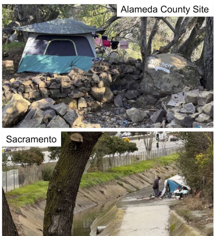
Natural hazards, socio-economic wellbeing, & ecology intertwine in California’s urban stream corridors (USCs), because these pathways are heavily relied on for housing, transportation, flood & pollution control, social & ecosystem services, water supply, and recreation (Haase, 2015). This is the USC hazard-human-ecosystem (HHE) nexus, because USCs pass from hills to coast through communities spanning the economic spectrum, with unhoused people, fish, birds, and mammals migrating along them, and with a multitude of natural hazards creating different vulnerabilities tied to landscape and socio-economic patterns. During winter 2023, 13 atmospheric rivers caused flooding that forced tens of thousands of people to evacuate and lose their belongings, including many unhoused people previously pushed into living and sleep along USCs. Meanwhile, USC aquatic and riparian habitats are being destroyed by floods, channelization, and pollution (SWQCB, 2011; Booth et al., 2016). Yet 5 months prior, drought, fire, and overheating were stressing USCs. While California’s climate has always been defined by climate and water supply variability (Griffin & Anchukaitis, 2014), we know climate change will exacerbate these extremes (Payne et al., 2020). Climate change is synergizing with the complex HHE nexus in USCs to further amplify extremes in ways that our USC communities and ecosystems are not resilient to. These challenges need to be planned for and met, especially considering the most climate-vulnerable, populous urban areas and the “iconic species” (CA 30x30 terminology) that co-exist there.
As exemplified by past critique of the management of the San Francisquito Creek USC in the Bay Area (Rofougaran & Karl, 2005), the best way to handle this type of complex problem is with a transdisciplinary framework. Transdisciplinary means that research not only crosses disciplines but also frames problems and solutions collaboratively with non-academic stakeholders (Groß & Stauffacher, 2014). Put another way, complex societal problems do not get solved through a linear process in which science is done first and then results are handed off to practitioners and policymakers for adoption, often without community engagement. Instead, there needs to be community engagement and involvement of scientists all the time. Our transdisciplinary team spanning academia, government, and nonprofit will address this complex and interconnected crisis adopting such 21st century best practices.
Study Area
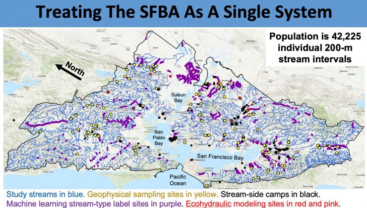
This study address the streams in the 9-county San Francisco Bay Area, excluding a few areas of small streams draining directly to the Pacific ocean and into some high-elevation lakes & reservoirs. The map below shows all of the locations for which we collected data of one type or another as part of this study.
Project Goals & Objectives
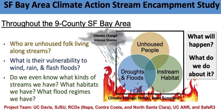
Our project goal was (and remains) to promote resilient and equitable urban stream corridors for our future through the creation and applied use of a systemic, regional framework for coping with the intertwining of hazards, humans, and ecology in the face of California’s climate change forecasts. This overall goal will be achieved through three transdisciplinary research objectives, each guided by a scientific question that addresses California’s climate action priorities.
The project was funded from August 1, 2023- July 31, 2026; it is now in a post-funding stage of outreach, communication, seeking new funding possibilities, and supporting others building on this work.
First, we aimed to improve our understanding of complex HHE interactions within and between USC types. Intensive survey campaigns spanning natural and social sciences will be carried out to provide a new, unique dataset and perspective on the HHE nexus in USCs. This dataset will then be used to produce a transdisciplinary USC typology and scale up with a ML modeling approach to a regional map showing the network pattern of USC types.
Second, we assessed the vulnerability of USCs to future changes in climate and socio-economic & ecological conditions by 2050, by running models to predict how the USC HHE nexus and regional USC pattern will change. Forecasting is an essential component of climate action research. It is time for forecasts to go beyond just climate variable predictions to an understanding of how climate will synergize with other drivers to change socio-economics and ecology, such as for vulnerable urban stream corridors.
Finally, we developed tools and partnered with local stakeholders to improve the resilience of our streams and the communities that live along them, particularly unhoused folks and iconic species caught in the USC HHE nexus in a changing climate. These actions will include (i) building local capacities serving unhoused folks and iconic species, (ii) improving the transdisciplinary functioning of regional stakeholders, and (iii) formulating policy and management recommendations using data and map products we generate. The three specific objectives were addressed concurrently, with some actions iteratively improved as deliverables from other components were accomplished, per the project timeline and milestones. We took broad, seemingly intractable questions about the future of USCs and leverages the expertise of 7 institutions to break them down into specific and answerable scientific questions overviewed below.
Project Logistical Framework
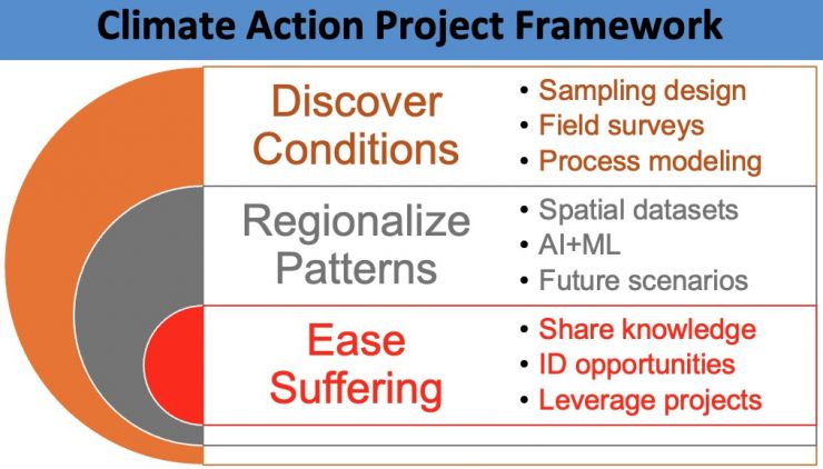
The survey campaigns were the largest and most comprehensive attempted for the state’s USCs. They provided a wealth of data, experience in regional transdisciplinary engagement, and interdisciplinary HHE insights. However, how can we use present-day field surveys to address climate action for a future California? The answer is through the use of a USC HHE typology that is sensitive to changing conditions we can forecast.
Typologies organize and prioritize information so that like entities can be matched up and addressed efficiently with a common framework, while unlike entities can be appropriately treated differently. They are often used globally for regional environmental management (Lane et al., 2017). They are the basis for California’s regional environmental flows framework (Lane et al., 2022). In this project, we developed a set of stream archetypes (sensu Cullum et al., 2016) for each USC type - spanning artificial and natural stream types- to study the details of each. These archetypes were then used in adaptive management to identify pathways to achieve climate resilience. Through trans-disciplinary engagement with archetypes, policy and management recommendations for USC types can be arrived at by consensus, including design guidance for NbS that benefit the most climate-vulnerable urban dwellers. Our activities have helped urban & climate planners, social service providers, & homeless-advocacy groups reduce negative impacts of unhoused living on the people experiencing it, while conversely helping reduce negative impacts of unhoused living on USCs & adjacent communities.
Study Research Components
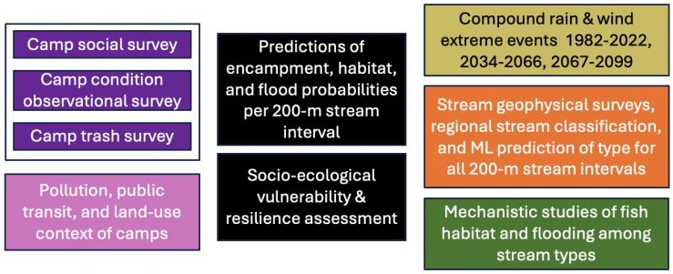
Along with the transdisciplinary activities, the academic research program involved a large and complex set of activities, illustrated in the graphic above and summarized below. On the left, activities address environmental sociology and land use were led by San Jose State University. On the right, activities address environmentla sciences, were led by University of California at Davis.
Environmental Sociology and Land Use Studies
As part of this project Prof. Costanza Rampini's team at SJSU collected 4 different types of social science data: land use data, visual surveys of homeless encampments, interview data with residents of homeless encampments, and litter/trash data. Over the past 3 years, the SJSU team visited 40 encampments throughout the Bay Area Counties, conducted 310 interviews with encampment residents, and participated in and collected trash/litter data at 22 river clean up events. An extensive database about civil infrastructure, terrain, and socio-economic conditions was developed and used to address a variety of questions. The goal of the litter/trash surveys was to understand the impacts of homeless encampments on urban riparian ecosystems and stream health. The goal of the visual surveys and of the interviews with their residents is to understand the vulnerability and resilience of homeless encampments to extreme weather such as flash floods and heatwaves, while also understanding residents' relationships to one another and to the streams along which they live.
Environmental Sociology
Results from the 310 interviews, 40 encampment visits, and 22 trash surveys at clean-up events are currently being written up into scholarly journal articles. In the mean time, we can provide the following resources as policy briefs and preliminary results.
Policy Briefs
- How to run stream clean-ups in the vicinity of streamside encampments.
- Encampment trash management systems
Videos
- Prof. Rampini (SJSU) webinar, "A radical rethink: homelessness, climate change, and creek restoration."
- Prof. Rampini (SJSU) Lab Group's Trash Management Systems Guidance Information Video
Outreach Media Describing Project
- UC Davis media video about this project
- Linksploration Bay Area Podcast, Exploring the Many Paths to a Greener Future. Episode “Resilient & Equitable Urban Streams: The Ecology of Urban Waterways”
- SJSU Washington Square Magazine article, "Mapping survival: Unhoused communities, urban streams, and climate change"
Preliminary Results
Email Prof. Pasternack for list of findings for use in policy planning.
Land-Use & Urban Planning
The goal of the land use and urban planning work was to conduct a geospatial analysis of where homeless encampments are located within our urban stream corridors, and their proximity to high pollution areas and transportation hubs.
LU&UP Results
- Alexander, S., Williamson, B., Wootton, J., Rampini, C., Pasternack, G. B., Jin, Y., Storesund, R., Lacan, I. 2026. Pushed to the Edges? Electivity Patterns of Urban Stream Homeless Encampments in Environmentally Burdened Areas. Journal of Urban Affairs. DOI: 10.1080/07352166.2026.2702435.
- Alexander, S., Wootton, J., Rampini, C., Pasternack, G. B., Jin, Y., Moreno, S., Lim, C., Patzek, L., Storesund, R., Lacan, I. revised-submitted. Walkability, Transit, and the Spatial Logic of Homeless Encampments: Evidence from the Bay Area. Cities. (email Prof. Pasternack for a preprint)
Integrating Physical & Cultural Geography
While our land use and urban planning research about where streamside encampments are located found important connections to individual factors, including pollution and transit access, this part of the research program takes a holistic look at a very large number of possible contributing factors spanning, terrain, civil infrastructure, and socio-economic variables. A MaxEnt multivariate model was made that accurately predicted streamside encampment locations using combinations of such variables. The work also identifies which variables are most important. Results were presented at the 2026 Science Day conference of the California Council on Science and Technology and ar being written up for publication at this time.
Environmental Science Studies
We have produced a number of results that are in various stages of production and publication for distribution. As a starting point, we have produces several videos and participated in media stories, available at the links below.
Hydroclimatological studies have been carried out with a focus on wet-seaon hazards and vulnerabilities associated with wind, rain, and flooding. Details are provided on the compound wind-rain storms web page.
Studies about Bay Area stream classification are provided on the SFBA stream types web page.
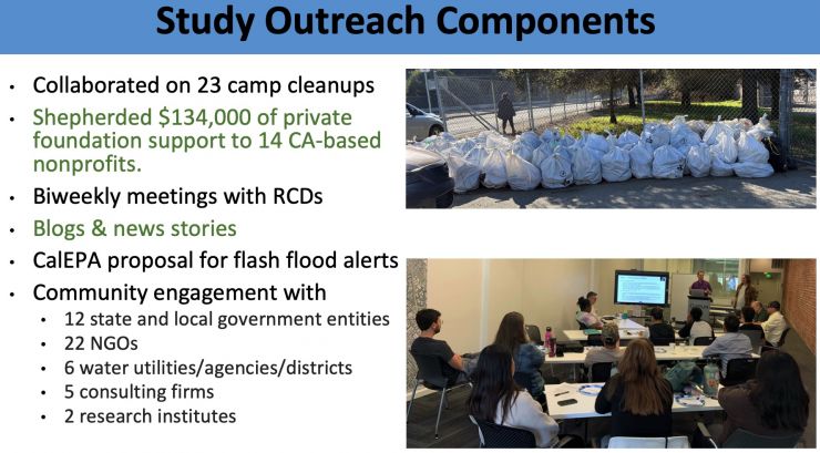
Project Outreach Components
The list below is preliminary and growing.